Forestry
 Specific BMP guidelines apply in Alabama for timber harvesting surrounding streams and wetlands. The tables provided here offer essential information to planning and implementing environmentally responsible harvesting techniques in various scenarios.
Forestry best management practices (BMPs) are implemented to minimize nonpoint source pollution (NPSP) that can occur on active and completed timber harvests. NPSP in forestry consists of sediment reaching waterways and wetlands via erosion from forest roads, skid trails, and stream crossings. Specific BMPs may be required to maintain silvicultural exemption from certain provisions of the Clean Water Act.
BMPs are implemented during active timber harvests and at harvest close-out. The primary goal is to minimize NPSP from entering waterways and wetlands. This means that preparations related to streamside management zones (SMZs), stream crossings, forest roads, and skid trails must begin during the pre-harvest planning stage.
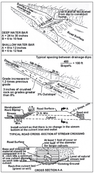
Figure 1. Diagrams on installing water bars, broad-based dips, and culverts. The culvert diagram was modified to the Alabama BMP manual specifications of at least 1 foot of cover above the culvert or half the diameter for larger culverts.
The first step in the planning stage is to determine if there will be any stream crossings and the type of stream that will be crossed (table 1). There are specific BMP guidelines for perennial (table 2), intermittent (table 3), and ephemeral (table 4) streams. Harvesting in wetlands need to follow Alabama BMP guidelines (table 5) along with the fifteen U.S. Army Corps of Engineer baseline BMPs for forest roads and stream crossing construction in wetlands (table 12).
Stream crossing methods can be installed as temporary or permanent crossings and consist of log crossings, fords, culverts, and bridges (table 6). Culvert diameters need to account for peak flow and the Alabama BMP guidelines, which recommend culvert sizes based on drainage (watershed) area (table 7). Temporary crossings need to be removed after the harvest.
Forest road and skid trail BMPs need to be planned out prior to harvesting and implemented and maintained during and after harvesting (close-out BMPs) (tables 8 to 10). Water diversion devices, such as water bars, broad-based dips, and turnouts, are recommended BMPs to reduce erosion and sedimentation from forest roads and skid trails (table 11 and figure 1).
The complete forestry BMP manual is available on the Alabama Forestry Commission (AFC) website at www. forestry.alabama.gov/Pages/Management/Forms/2007_ BMP_Manual.pdf.
Table 1. Stream-type Definitions
| Stream Type | Flow | Channel | Channel Material | Harvest Planning |
|---|---|---|---|---|
| Perennial | Maintains flow or pools throughout most of the year (>80% of the year) | Well- defined | Scoured, no organic buildup | Can be identified on topography maps (solid blue line) |
| Intermittent | Seasonal flow (10%– 80% of the year) | Typically defined but sometimes difficult to identify | Scoured, lacks organic buildup | Usually can be identified on topography maps (solid or dashed blue line) |
| Ephemeral | Only flow after rainfall | Not well- defined | Mostly soil, organic buildup | Usually not identified on topography map |
Table 2. BMPs for Perennial Streams
| Management Item | Best Practice |
|---|---|
| Stream Crossings | Minimize number of crossings. |
| Crossing Design | Allow for stream flow and fish passage. |
| Federal BMPs | Application necessary to maintain CWA Section 404 exemption. |
| Streamside Management Zones (SMZ) | Minimum width of 35 feet on each side of stream; mark SMZ prior to harvesting. Wider SMZ recommended on steep terrain and highly erodible soils (at least 50 feet or more per side where they flow into a pond, lake, or other large body of water) to prevent sedimentation flow that causes these water bodies to become silted in. |
| SMZ Tree Cover | Maintain 50% canopy cover (partial harvest only) within 35 feet of the stream. |
| Forest Roads and Skid Trails | Other than crossing locations or when partial harvesting, prevent machine traffic at least 35 feet from stream bank. |
| Close-out | Remove temporary crossings, stabilize exposed soil, and divert runoff from roads and skid trails from reaching the stream. See forest road tables for specific BMPs to divert runoff (tables 8–11 and figure 1). |
Table 3. BMPs for Intermittent Streams
| Management Item | Best Practice |
|---|---|
| Stream Crossings | Minimize number of crossings. |
| Crossing Design | Allow for stream flow and fish passage. |
| Federal BMPs | Application necessary to maintain CWA Section 404 exemption. |
| Streamside Management Zones (SMZ) | Recommended to leave a minimal width of 35 feet on each side of stream (see SMZ tree cover); mark SMZ prior to harvesting. Wider SMZ recommended on steep terrain and highly erodible soils (at least 50 feet or more per side where they flow into a pond, lake, or other large body of water) to prevent sedimentation flow that causes these water bodies to become silted in. |
| SMZ Tree Cover | Vegetative: residual tree cover is not required, but other vegetation and organic debris need to be left to protect forest floor. Partial harvest recommended to avoid water quality degradation |
| Forest Roads and Skid Trails | Other than crossing locations or when partial harvesting, prevent machine traffic at least 35 feet from stream bank. |
| Close-out | Remove temporary crossings, stabilize exposed soil, and divert runoff from roads and skid trails from reaching the stream. See forest road tables for specific BMPs to divert runoff (tables 8–11 and figure 1). |
Table 4. BMPs for Ephemeral Streams
| Management Item | Best Practice |
|---|---|
| Stream Crossings | None required but is recommended to minimize traffic in these areas. |
| Forest Roads and Skid Trails | Minimize traffic in these areas; limit soil disturbance. |
| Streamside Management Zones (SMZ) | None required. |
| Close-out | Stabilize exposed soil and divert runoff. If temporary crossing is needed, remove the crossings and debris. |
Table 5. BMPs for Wetlands
| Management Item | Best Practice |
|---|---|
| Stream Crossings | Minimize number of crossings. |
| Crossing Design | Allow for surface and subsurface water flow. |
| Federal BMPs | Application necessary to maintain CWA Section 404 exemption. |
| Streamside Management Zones (SMZ) | Minimum width of 35 feet on each side of stream. Identify channels in the wetland and mark SMZs prior to harvesting. |
| SMZ Tree Cover | Maintain 50% canopy cover (partial harvest only) within 35 feet of the wetland stream channel. |
| Forest Roads and Skid Trails | Minimize road length and avoid machine traffic that can alter surface and subsurface water flow. Use logging mats or slash when needed. |
| Close-out | Remove temporary crossings. Remove logging mats and slash on roads and trails. Stabilize exposed soil. Divert runoff from roads and skid trails from reaching the wetland SMZ. See forest road tables for specific BMPs to divert runoff (tables 8–11 and figure 1). |
Table 6. Stream-Crossing Methods
It is recommended that all stream approaches and banks be stabilized with hay, enviro mats, grass seed, and hay bales to prevent soil movement back into the stream.
| Crossing Type | Permanance | Method |
|---|---|---|
| Log crossing | Temporary | Place solid logs into channel. Do not use small tops, limbs, brush, or dirt. Remove crossing after harvest and apply close-out BMPs when removed. |
| Fords | Temporary/permanent | Use when streambed is firm, banks are low, and stream is shallow. Blade back banks from water to improve approach. Stabilize the approach and stream bottom with rock or combination of geotextile and rock. |
| Culvert | Temporary/permanent | Place culvert on stream bottom. Don’t excavate below the natural stream bottom. One large pipe is better than several smaller pipes. Culverts need to extend at least 1 foot past the fill on either end. Stabilize fill materials with seed, mulch, sandbags, rip-rap, or concrete. Cover culvert with soil at least 12 inches or half of culvert diameter for larger culverts. Remove temporary culvert after harvest and apply close-out BMPs to the road or skid trail. Maintain permanent crossings. Recommended culvert diameters can be found in table 7. |
| Bridge | Temporary/permanent | Least disruptive crossing method to streamflow and erosion. Stabilize banks and fill materials. Must permit passage of high flow events. Remove temporary crossing after harvest and apply close-out BMPs. |
Table 7. Recommended Culvert Diameter Based on the Drainage Area Above the Crossing
| Drainage Area (ac) | Lower Coastal Plain (in) | Upper Coastal Plain (in) | Piedmont (in) | Mountains (in) |
|---|---|---|---|---|
| 10 | 12 | 12 | 12 | 18 |
| 50 | 30 | 18 | 30 | 36 |
| 100 | 48 | 30 | 42 | 48 |
| 200 | 60 | 42 | 54 | two 48 |
Table 8. Permanent Forest Roads
| Management Item | Best Practice |
|---|---|
| Forest Road Construction | Design roads to meet traffic and safety requirements. Merchantable timber should be cleared prior to using grubbing equipment. Remove stumps, logs, slash, and other organic debris. Minimize exposure of soil on banks and roadsides and stabilize areas with erosion potential. Install water diversion devices (table 11 and figure 1) at the time the road is constructed. Water drainage should be dispersed onto undisturbed forest areas when possible. |
| Surface Drainage | Slope or crown road surfaces between 2% and 4%. |
| Stream Crossings | Install proper crossing for expected traffic and peak storm flow (tables 1 - 7 and figure 1). |
| Road Surface Erosion | Gravel or seed/mulch highly erodible areas of roads. |
| Maintenance | Periodic inspection should start immediately after construction. After completion of timber harvest, areas that were rutted should be regraded and stabilized with water diversion devices, and the correct function of water bars, broad-based dips, turnouts, and stream crossings should be maintained. |
| Traffic Control | Limit traffic when possible, especially during wet conditions. |
Table 9. Temporary Harvest Roads
| Management Item | Best Practice |
|---|---|
| Forest Road Construction | Design roads to meet traffic and safety requirements. Merchantable timber should be cleared prior to using grubbing equipment. Remove stumps, logs, slash, and other organic debris. Minimize exposure of soil on banks and roadsides and stabilize areas with erosion potential. Install water diversion devices (table 11 and figure 1) at the time the road is constructed. Water drainage should be dispersed onto undisturbed forest areas when possible. |
| Surface Drainage | Slope or crown road surfaces between 2% and 4%. |
| Stream Crossings | Install proper crossing for expected traffic and peak storm flow. Removing crossing after harvest (tables 1 - 7 and figure 1). |
| Road Surface Erosion | Gravel or seed/mulch highly erodible areas of roads. |
| Close Out | Remove temporary stream crossings. Install new and stabilize existing water diversion devices where needed. Seed/mulch or apply slash to highly erodible areas of roads. Slash is an effective road closure BMP technique that reduces erosion. |
| Traffic Control | Block/limit traffic with logging debris, gates, or berms. |
Table 10. Skid Trails
| Management Item | Best Practice |
|---|---|
| Skid Trail Construction | Select areas that provide good drainage and avoid problem areas such as wet areas and steep slopes. Install skid trails along the contour when possible. Install temporary stream crossings whenever crossing a stream (tables 1–7 and figure 1). |
| Areas of Concern | When soils are saturated or when harvesting in wet areas, use low ground pressure equipment to minimize rutting and soil compaction or use a technique such as mat logging (logs temporarily placed on the ground that skidders can drive over or moveable mats designed for skidding across wet sites). Minimize skidder operation in wetlands. |
| Close-Out | Remove temporary stream crossings; install water diversion devices where needed; and seed/mulch or scatter slash on highly erodible areas. |
Table 11. Water Diversion Device Spacing for Water Bars and Broad-based Dips Based on Percent Slope of Forest Road or Skid Trail
| Percent Slope (%) | Distance Between Water Bars (ft) | Distance Between Broad-based Dips (ft) |
|---|---|---|
| 3 | 200 | 235 |
| 5 | 135 | 180 |
| 10 | 80 | 140 |
| 15 | 60 | 125 |
| 20 | 45 | - |
| 30 | 35 | - |
| 40 | 30 | - |
Table 12. U.S. Army Corps of Engineer Baseline BMPs* for Roads and Stream Crossings Within Wetlands and Other U.S. Waters
*BMPs from Section 404, Corps of Engineers Permit Requirements, 40 CFR Part 233.22
| Baseline BMPs |
|---|
| Permanent roads, temporary access roads, and skid trails (all for forestry) in waters of the U.S. shall be held to the minimum feasible number, width, and total length consistent with the purpose of specific silvicultural operations and local topographic and climatic conditions. |
| All roads, temporary or permanent, shall be located sufficiently far from streams or other water bodies (except for portions of such roads which must cross water bodies) to minimize discharges of dredged or fill material into waters of the U.S. |
| The road fill shall be bridged, culverted, or otherwise designed to prevent the restriction of expected flood flows. |
| The fill shall be properly stabilized and maintained during and following construction to prevent erosion. |
| Discharges of dredged or fill material into waters of the U.S. to construct a road fill shall be made in a manner that minimizes the encroachment of trucks, tractors, bulldozers, or other heavy equipment within waters of the U.S. (including adjacent wetlands) that lie outside the lateral boundaries of the fill itself. |
| In designing, constructing, and maintaining roads, vegetative disturbance in the waters of the U.S. shall be kept to a minimum. |
| The design, construction, and maintenance of the road crossing shall not disrupt the migration or other movement of those species of aquatic life inhabiting the water body. |
| Borrow material shall be taken from upland sources whenever feasible. |
| The discharge shall not take or jeopardize the continued existence of a threatened or endangered species as defined under the Endangered Species Act or adversely modify or destroy the critical habitat of such species. |
| Discharges into breeding and nesting areas for waterfowl, spawning areas, and wetlands shall be avoided if less harmful alternatives exist. |
| The discharge shall not be located in the proximity of a public water supply intake. |
| The discharge shall not occur in areas of concentrated shellfish production. |
| The discharge shall not occur in a component of the National Wild and Scenic River System. |
| The discharge of material shall consist of suitable material free from toxic pollutants in toxic amounts. |
| All temporary fills shall be removed in their entirety and the area restored to its original elevation. |
 Richard Cristan, Extension Specialist and Assistant Professor, School of Forestry and Wildlife Sciences and Carey Potter, BMP Coordinator, Alabama Forestry Commission
Reviewed July 2022, Timber Harvesting Guidelines for Forestry Best Management Practices, FOR-2009