Fish & Water
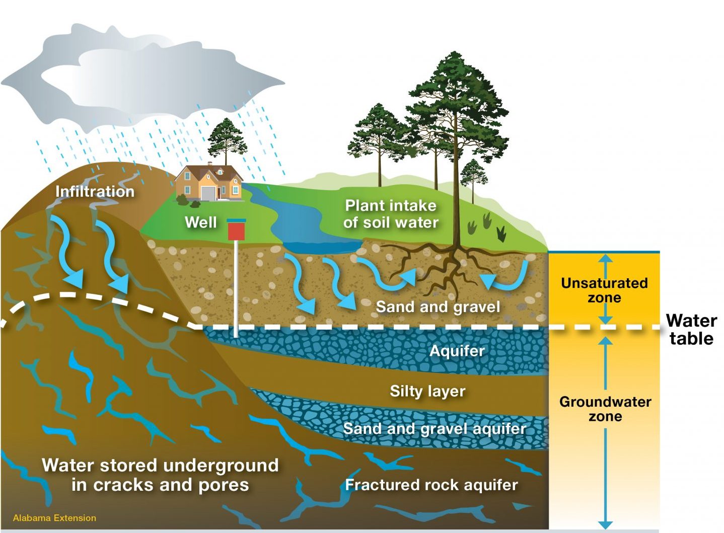
A significant amount of water in the water cycle is hidden from day-to-day existence in the ground below people’s feet. However, it is only found in usable quantities in certain places underground called aquifers.
Helpful Terminology
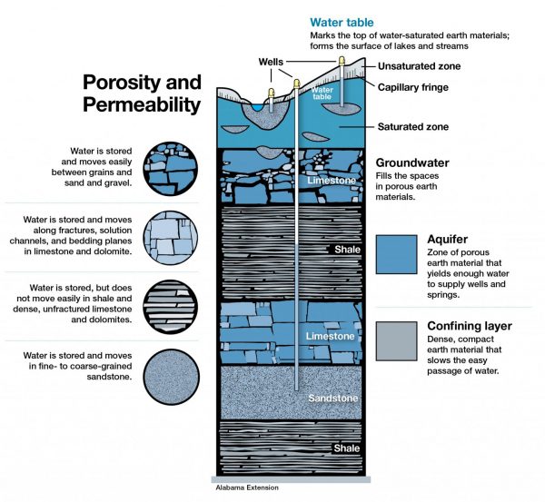
- Aquifer – a body of permeable material where groundwater is present and fills all pore spaces (is saturated)
- Confining Layer – a layer of material with low permeability that bounds an aquifer and limits or inhibits the flow of water out of the aquifer
- Unconfined Aquifer – an aquifer that is connected to the surface (at atmospheric pressure) and thus its upper surface can rise and fall
- Unsaturated Zone – the portion of the subsurface above the groundwater table. The soil and rock in this zone contain air as well as water in its pores.
- Saturated Zone – encompasses the area below ground in which all interconnected openings within the geologic medium are completely filled with water
- Confined Aquifer – aquifers in which an impermeable dirt/rock layer exists that prevents water from seeping into the aquifer from the ground surface located directly above
- Artesian Well – a well from which water flows under natural pressure without pumping
- Permeability – a measure of the degree to which the pore spaces are connected
- Porosity – a measure of the void spaces in a material, measured as a fraction of the volume of voids over the total volume
- Consolidated Rock – rock that is firm and coherent, solidified, or cemented and that has not been decomposed by weathering
The Movement of Water
Groundwater has been filtered and purified naturally through layers of soil, sand, and rocks as it passes through the layers of the Earth into aquifers. Aquifers are rarely underground lakes or rivers as people might think. The vast majority of groundwater is found between grains in rocks, soil, and sediment. How easily water can flow through an aquifer also determines its ability to provide water to a well. Many rock formations are fractured, and large amounts of water can be contained in those fractures.
Aquifers can be broken down into two types: unconfined and confined.
An unconfined aquifer is an aquifer that is connected to the surface (at atmospheric pressure) and thus the upper surface can rise and fall. Water flows through the surface and downward through small spaces and fractures to fill gaps between rocks and sediment. The spaces that become empty or partially filled with water are the unsaturated zone, and those that are filled with water are the saturated zone. The top of the saturated zone is the water table. In these aquifers, the position of the water table may vary depending on the amount of precipitation events (table gets higher). These aquifers are also high susceptible to seasonal precipitation changes and changes associated with withdrawing groundwater.
Confined aquifers are “sandwiched” or bounded above and below by impermeable beds or by beds of very low permeability (confining layers). Water does not enter these aquifers as easily as it does for unconfined aquifers. Water enters the rocks of the confined aquifer at a higher elevation and flows downslope to fill the aquifer layer. When a well is drilled into a confined aquifer, the pressure forces the water in the well to rise above the top of the aquifer itself. If the pressure is great enough, the water will actually flow from the well at the ground surface without having to be pumped. Such flowing wells are common in and near the flood plains of major streams in the southern half of the state and are sometimes called artesian wells. In fact, Prattville, Alabama is nicknamed The Fountain City because of the many artesian wells that were once found in the area.
 Groundwater is a resource that is replenished by rainfall at rates that vary from quickly to centuries. Some groundwater in Alabama is over 50,000 years old. Precipitation eventually adds water to the aquifer, recharging it. Alabama on average receives more than 55 inches of rainfall each year. For confined aquifers that cannot be locally recharged by rainwater at the Earth’s surface, it may be recharged somewhere miles away. This can happen when the aquifer is exposed to the surface where the confinement layer is absent, allowing water to filter underground. Recharge can also occur along streams or wherever water is in contact with the aquifer.
Groundwater is not evenly distributed throughout the state. In some places the water is shallow and abundant. In other places, it is deeper and harder to find. Occasionally, local shortages may occur in some areas where the demand is great, causing serious problems. Groundwater availability varies from region to region and is controlled primarily by various geologic factors, such as permeability, porosity, type, and structure of the rocks comprising the aquifer.
Rocks are typically classified as consolidated rock (bedrock) –which might include sandstone, limestone, and granite– or as unconsolidated rock, which consists of granular materials like sand, gravel, or clay.Rocks have different porosity and permeability characteristics, which means that water moves around differently depending on the rocks below ground. If water cannot get to the well at the same rate as the pump operates, it will limit the pumping rate, interrupting the water supply. Whether or not rocks are porous (the size and number of void spaces) or permeable (the relative ease with which water moves through spaces) will impact how much water is stored.
There is not always a direct relationship between the depths of rocks and their water-bearing capacity. For example, a dense granite close to the surface may yield little to no water, while porous sandstone hundreds of feet below the surface may yield hundreds of gallons of water per minute. On average, rocks lose permeability and porosity as their depth below the Earth’s surface increases. This is because the weight of overlying rocks pushes closed the cracks and pores of rocks at a great depth. If you look at rocks exposed by road cuts or exposed by streams, you can see the types of openings in rocks in which groundwater can be stored and transmitted. Some bedrock exposures reveal spaces in layers extending for miles.
Aquifers can also be grouped according to the way that water moves through them. Aquifers transmit water by porous flow, conduit flow, fracture flow, or by a combination of these.
- Porous flow is typical of aquifers composed of sand or sandstone. These aquifers are made up of sand-sized particles of other rocks that were broken down by erosion and then transported to their present location by wind or water and deposited. Water is stored in and moves through the open spaces, or pores, between the individual sand grains.
- In conduit flow, water actually flows through underground channels, or conduits, in rocks (often limestone and dolomite). Springs are common in limestone aquifers, discharging water where water-filled channels meet the surface. Limestone aquifers have several potential disadvantages. Because these openings are irregular in shape and distribution, groundwater flow can be unpredictable and move extremely fast, sometimes up to several thousand feet per day through the larger channels. The water table in limestone aquifers may rise and fall rapidly in response to pumping and precipitation events. Additionally, limestone aquifers often produce hard water, meaning it can contain large quantities of dissolved calcium and magnesium.
- Aquifers characterized by conduit flow can also be fractured, which enhances the permeability of these aquifers. In nonporous rocks, fractures may be the only way water can get through. These fractures also may or may not be well connected.
More Information
Interested in learning more about private well water? Visit the Private Well Program page at www.aces.edu.