Fish & Water
Many people drink groundwater every day, whether they know it or not. When turning on a faucet in Dothan, Greenville, Ozark, Selma, or Montgomery, just to name a few cities, that person is probably drinking groundwater. Many people depend on groundwater for drinking water because it is so readily available in many parts of Alabama.
Groundwater in Alabama
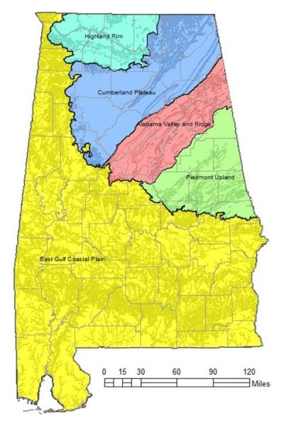
Geological Survey of Alabama
Image credit: https://www.gsa.state.al.us/
Alabama is divided into five hydrogeologic provinces: the East Gulf Coastal Plain, Piedmont Upland, Valley and Ridge, Cumberland Plateau, and Highland Rim. These hydrogeologic provinces are closely related to the physiographic provinces and therefore influence the way water moves and is stored in groundwater.
The hydrogeologic provinces are defined on the basis of differences in water-bearing properties of rocks, rock type, structural geology, and physiography. These characteristics determine the types of aquifers in these areas.
Coastal Plain
The Coastal Plain is by far the largest and most populous hydrogeologic province in the state. The presence and availability of groundwater in this region is quite high. Some wells can yield up to several thousand gallons of water per minute (gpm). The average production of wells in this area is higher than any other province in Alabama.
Major groundwater users include the cities of Dothan, Enterprise, Jackson (supplied by a spring), Montgomery (which also uses surface water), Prattville, Selma, and Troy. Residents of the Coastal Plain, while including only 44 percent of the state’s population, account for approximately 63 percent of the total groundwater use.
The per capita use is high primarily because of agricultural activity. While this area is typically high water yielding, some users near the northern area of the Coastal Plain have to augment their groundwater supplies by developing other sources, because of thin rock layers that cannot store large quantities of water.
Further south in the Coastal Plain is a part of Alabama that has dark, dense soils that are sticky when wet. This area is underlain by chalk, a variety of limestone, which makes for a poor aquifer. Groundwater from subsurface sand and limestone is the primary water source for the City of Dothan and is an important source to people living in an area from Henry County to southern Choctaw County. Subsurface sands also supply groundwater to communities in Escambia, Washington, Baldwin, and Mobile counties.
In areas of the Coastal Plain located near the Gulf Coast, contamination of fresh groundwater supplies by saltwater intrusion is a problem. Saltwater occurs at relatively shallow depths near the coast. Coastal freshwater aquifers can become contaminated if wells in these aquifers are pumped heavily, or over pumped, enough to draw saltwater into the wells. This issue of saltwater intrusion is a problem in southern Baldwin County and can affect any coastal area.
Piedmont Upland
The Alabama Piedmont Upland is the southernmost exposure of a vast physiographic province that forms the foothills of the Appalachian Mountains and stretches all the way to Pennsylvania. The ancient crystalline rocks of the Piedmont are igneous and metamorphic rock. Rocks in Piedmont do not hold much water compared to the sands and limestones of the Coastal Plain. Anniston, a large city of this province, uses water from Coldwater Spring, one of the largest springs in the state. Even though Anniston is in the Piedmont, Coldwater Spring is located in the Valley and Ridge province.
Valley and Ridge
The Valley and Ridge province is made up of folded and faulted sedimentary rocks (limestones, dolomites, sandstones, and shales) and marks the southern end of the Appalachian Mountains. Aquifers in the Valley and Ridge may be dominated by porous, conduit, or fracture-controlled flow, depending on the rock type. Groundwater is abundant in the Valley and Ridge, with these aquifers capable of producing more than 100 gpm. A few wells can yield as much as 1,600 gpm. Because most of the valleys are underlain by limestone and dolomite, aquifers in these areas are relatively susceptible to groundwater contamination from the surface.
Cumberland Plateau
The Cumberland Plateau in north central Alabama is underlain by relatively flat-lying rocks. The Pottsville Formation, which consists of interbedded sandstone and shale, is the major aquifer in the Cumberland Plateau, with the Bangor Limestone and Hartselle Sandstone supplying significant amounts of groundwater in some parts of the province. Water from the Pottsville contains enough iron in places to stain fixtures and affect the taste of the water. Water from the Bangor and the Hartselle is often hard. Individual wells in the province can yield as much as several hundred gallons per minute, but 20 gpm or less is typical. Springs in the Cumberland Plateau are moderately common, yielding 10 to 100 gpm of water from limestone, sandstone, and shale.
Highland Rim
As in the case in many areas in Alabama, groundwater is unevenly distributed in the Highland Rim. High-capacity wells, producing from 100 to more than 1,000 gpm, occur in the limestones and dolomites of the Fort Payne-Tuscumbia aquifer system in the northern part of the Highland Rim, and in the Bangor limestone in the southern part. The Hartselle sandstone and several other aquifers of local importance supply minor amounts of groundwater to the southern part of the province, mostly from wells producing 10 gpm or less.
The major aquifers in the Highland Rim province contain significant amounts of limestone. Caves and sinkholes are common, and contamination of groundwater is a serious concern. Much of the groundwater in this region is hard and may contain iron, carbon dioxide, or hydrogen sulfide. Huntsville is the largest groundwater user in this region, getting most of its water from two wells and Brahan Spring (Huntsville Big Spring). In addition, the Madison County Water Authority and the Limestone County Water Authority depend entirely on groundwater for their water supply.
More Information
Interested in learning more about private well water? Visit the Private Well Program page at www.aces.edu.