Crop Production

Soil sampling is a crucial component of nutrient management in agricultural fields. This publication covers information on different types of precision soil sampling strategies that can be used for site-specific management of soil pH and nutrients for improved crop yields.
Traditional soil sampling involves randomly taking one or more composite samples within a field and using the soil test results to uniformly apply lime and fertilizer across the entire field. However, most agricultural fields, especially in the southeastern United States, have inherent nutrient variability due to differences in soil physical and chemical properties.
Traditional soil sampling fails to depict this variability and at best provides an average representation of the soil pH and nutrient levels within agricultural fields. Consequently, nutrient recommendations based on this soil sampling approach (consisting of a single-rate, uniform application) often result in underapplication and overapplication of lime and fertilizer in large areas within the field. This leads to inefficient nutrient management and suboptimal crop yields.
Figure 1 illustrates traditional soil sampling and its limitations in depicting the existing spatial variability within a field. The map in figure 1(a) shows traditional sampling, where several soil cores collected within a field are combined to make a composite sample. The map in figure 1(b) shows the average soil pH of 5.4 based on the soil test results for the composite sample. Lastly, the map in figure 1(c) shows the actual soil pH variability within this field, which differs considerably from the average soil pH indicated by the traditional soil sampling.
-
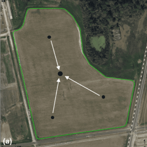
- Figure 1. (a) Map illustrating a traditional soil sampling method.
-
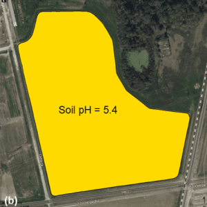
- Figure 1. (b) Map showing an averaged soil pH value for the whole field based on the composite soil sample.
-
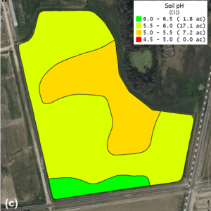
- Figure 1. (c) Map depicting the actual soil pH variability within the field, determined using a precision (grid) soil sampling method.
Considering this soil pH variability, a uniform rate of lime applied across the field based on soil test results from traditional soil sampling would result in underapplication and overapplication in various areas within the field. This highlights the need for precision soil sampling to inform variable-rate applications in agricultural fields.
Precision Soil Sampling Strategies
In contrast to traditional soil sampling, where a single composite sample represents the entire field, precision soil sampling involves dividing a field into smaller areas of the same size or with similar soil and crop characteristics. Representative soil samples are then collected within each area to assess the soil pH and nutrient variability that exist within the field. These soil sample results are then used to inform variable-rate applications of lime and fertilizer for site-specific nutrient management. There are two main types of precision soil sampling strategies commonly used in precision agriculture: grid and zone.
Grid Sampling
The grid soil sampling method involves dividing the field into uniform-size grids (square or rectangular), as illustrated in figure 2(a), and collecting a composite soil sample, typically comprising eight to twelve soil cores from each grid. The grid map usually accompanies a map with centroid points marked for each grid, as shown in figure 2(b); this is often used to navigate to the center of the grids during sampling. Once the soil test values for each grid are received, these points are used to create spatial maps of soil pH and nutrient levels that depict variability across the field.
-
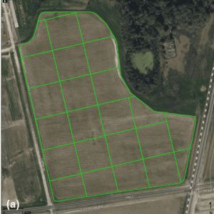
- Figure 2. Illustration of a grid soil sampling method. Map (a) shows a field divided into 2.5-acre grids.
-

- Figure 2. Illustration of a grid soil sampling method. Map (b) shows the center of each grid, which is commonly used to navigate to different grids within a field during soil sampling.
The size of sampling grids can range between 1 and 5 acres, but a smaller grid size of 2.5 acres or less is recommended to accurately capture variability in soil pH and nutrient levels within fields. Larger grid sizes (up to 5 acres) are often used in relatively uniform fields to reduce labor and sampling costs. Grid size can also vary based on the width of the application equipment (width of the grid as a multiple of the spreading swath) for more effective and uniform application within grids.
Grid sampling is one of the most commonly used soil sampling strategies in the southeastern United States as it is easy to implement and does not require additional spatial data or prior knowledge of historical field management.
There are several methods for collecting soil cores within grids depending on availability of sampling equipment, manual labor, and other factors. When soil samples are collected manually, point sampling is usually the preferred method, where eight to ten soil cores are collected in a circular pattern (in a radius of 30 to 50 feet depending on grid size) around the centroid point within a grid. In contrast, an S pattern (or Z pattern) is more common when soil samples are collected using an automated soil sampler mounted on a utility terrain vehicle (UTV). In this method, soil samples are collected at regular spacing intervals (50 to 100 feet) by starting from one corner of the grid and collecting soil cores within the grid in an S-shaped pattern.
Most consultants and precision ag service providers have their preferred sampling method that allows them to collect soil samples more efficiently and quickly across large fields. Regardless of the technique used for collecting samples, it is important to collect a sufficient number of soil cores (at least eight) that adequately represent soil properties within each grid.
Zone Sampling
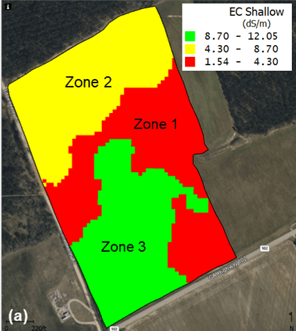
Figure 3. Illustration of a zone soil sampling method. Map (a) shows the field divided into different management zones based on soil EC.
The zone sampling method involves dividing the field into smaller areas (zones) that can be managed uniformly (figure 3). Soil samples are then collected within each zone to determine the average soil pH and nutrient levels. The number and resolution of management zones depend on the type and quality of data available for a field. It is typical to have three to five different management zones in most fields.
Generally, data layers such as soil texture, topography, aerial imagery, yield, soil electrical conductivity (EC), and any other historical management information can be used individually or in combination to delineate management zones. Figure 3(a) shows a soil sampling map for a field where zones are based on soil EC variability across the field.
In zone sampling, soil cores collected within each zone are combined to form a composite sample; therefore, a field may have only four to eight total samples. In some cases where the zones are considerably large, it is common to collect two or more composite samples within each zone and send those samples separately for soil test analysis.
While it is assumed that zones represent homogeneous areas that can be managed uniformly, it is good practice to divide larger management zones into smaller areas (no larger than 10 acres) for soil sampling as it provides a better estimation of nutrient variability within fields.
The map in figure 3(b) shows an example in which composite soil samples will be collected at three to five different locations within each zone. It is important to note that each composite sample comprises eight to twelve soil cores collected from a representative area within that zone.
Even when two or more composite samples are collected from each zone, the overall number of samples with zone sampling is considerably less than in grid sampling. This helps to lower the overall costs and labor associated with soil sampling and analysis.
In contrast to grid sampling, where no knowledge of field history is required, zone sampling is mainly used when data representing in-field spatial characteristics, such as soil EC, yield, or soil texture, is available and/or field history is known for multiple years (preferably 3 to 5). In some fields, changes in topography can also be used to create zones for soil sampling. Overlaying aerial imagery or other data layers can also help in refining management zones and enabling more precise soil sampling.
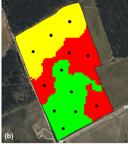
Figure 3. Illustration of a zone soil sampling method. Map (b) shows various soil sampling locations, each representing a composite sample within different zones.
While there are no established methods for collecting soil samples in zone sampling, one of the most common techniques is to follow a zigzag travel pattern through the zone, randomly collecting soil cores at regular intervals (a certain distance apart based on the size of the zone). This is somewhat similar to collecting soil samples across a large uniform field, but in smaller predefined areas (zones) within the field.
Similar to grid sampling, an important consideration during zone sampling is to collect enough soil cores to get a composite sample that accurately represents nutrient levels within a given zone. As a reference, at least ten to fifteen cores should be collected for zones of 10 acres or less and the number of soil cores should be increased accordingly for zones larger than 10 acres.
Choice of Precision Soil Sampling Strategy
A common question when choosing a soil sampling strategy is which method—grid or zone—is more effective. The answer is not always as straightforward as choosing one method, as both can be very useful and provide valuable insights into spatial nutrient variability. The best sampling method mainly depends on the amount of variability and historical data available for a given field.
In general, grid sampling should be used in all newly cropped fields; in fields that have been brought back into production after a few years; in fields with past management issues; or in any field where a baseline of nutrient variability needs to be established. In subsequent years, this baseline information should be used in conjunction with other data, such as soil type, soil EC, topography, aerial imagery, or yield, to gradually transition to zone soil sampling, as it tends to provide a better combination of cost and effectiveness for most situations.
While grid sampling is generally more effective in depicting nutrient variability when smaller grid sizes (1 to 2.5 acres) are used, it may not be cost-effective to do so every year, as this translates to a greater number of samples and higher sampling costs. Using management zones, especially those based on yield or in-season aerial imagery, can also provide insights into how fertilizer and lime management affect different areas of the field over time compared to arbitrarily placed grids. Therefore, the best approach may be to initially conduct soil sampling on smaller grids (2.5 acres or less) to determine baseline nutrient levels and then transition to management zones over the next few years.
Ideally, grid sampling should be conducted every 4 to 5 years to generate high-resolution nutrient maps for fields and to evaluate whether zone soil sampling is still effective in depicting nutrient variability and does not miss any low- or high-nutrient areas within the fields. For best results, both grid and zone sampling strategies should be incorporated into growers’ long-term plans for improving site-specific nutrient management on their farms.
Considerations for Implementing Precision Soil Sampling
Most best practices recommended for traditional soil sampling, including maintaining a uniform sampling depth and sampling at the same time every year, are equally important for precision soil sampling and must be followed to ensure data quality. However, unlike traditional soil sampling, implementing precision soil sampling on a farm requires some specific knowledge and technical expertise to create and analyze spatial data, utilize GPS-enabled hardware and software, and perform variable-rate applications. Listed below are some of these considerations that growers should be aware of for effective adoption of precision soil sampling on their farms:
GIS software. Using precision soil sampling requires use of geographic information system (GIS) software to create soil sampling maps (grid and zone) and nutrient maps to visualize the variability within the field. There are several GIS software programs (computer and web-based) available for spatial data management, but most of them have a yearly subscription fee. While several mobile apps are also available for precision soil sampling (especially grid), their functionality is often limited. Before investing in GIS software, it is best to consult with several different precision ag/technology providers to understand software capabilities and subscription costs.
GPS hardware. In addition to GIS software, a GPS-enabled handheld device is required to upload soil sampling maps and navigate to different grids or zones within the field to collect soil samples. This can be any handheld device capable of displaying spatial data and current position. Most tablets and iPads today are equipped with GPS capabilities, allowing them to be utilized for precision soil sampling. However, not all GIS software has a mobile version or can work on mobile devices, so it is best to check compatibility between the GIS software and GPS hardware to be used for precision soil sampling.
Technical expertise. Utilizing both GPS-enabled devices and GIS software for precision soil sampling requires some basic technical expertise to view, manipulate, analyze, and interpret spatial data. For some users, learning to use GPS equipment and GIS software may require a significant amount of time and effort. Therefore, it is essential to understand the level of knowledge and expertise needed to implement precision soil sampling and create variable-rate prescription maps based on soil test results.
For most growers, awareness of various precision soil sampling strategies and how each could be applied to their farm is beneficial. However, in most cases, the best option for implementing precision soil sampling may be to work with a local crop consultant or agricultural technology provider.
Equipment capabilities. The end product of the precision soil sampling process is variable-rate prescription maps for lime and other nutrients. It is best to check if the application equipment (broadcast spreader) is equipped with the appropriate variable-rate technology and can apply varying rates of lime and fertilizer. Another important consideration is the application equipment’s capabilities in terms of changing rates, especially when traveling at faster speeds.
Fields with high nutrient variability or samples taken on smaller grid sizes usually results in prescription maps with multiple small areas with different rates. In such cases, it is better to combine the small, adjacent areas within the field to create a large area where fertilizer application can be performed more accurately and uniformly with the spreader than performing an inefficient application across the whole field.
Summary
Precision soil sampling is essential to determine spatial nutrient variability in agricultural fields and perform variable-rate applications for site-specific nutrient management. Both grid- and zone-based soil sampling are effective methods that should be utilized accordingly based on the prevalent nutrient variability and the amount of historical data available for the fields.
For accurate representation of soil pH and nutrient variability in most fields, sampling grids should be 2.5 acres or less for grid sampling, and management zones should be 10 acres or less for zone sampling. In both cases, an adequate number of soil cores (eight to twelve) should be collected within each grid or zone to make a composite sample.
Ideally, grid sampling should be conducted every 4 to 5 years in each field, while zone sampling should be used in between to be more effective with both nutrient applications and sampling costs.
Factors such as knowledge and technical expertise required to create and work with spatial maps, as well as application equipment capabilities need to be considered before implementing and adopting precision soil sampling on a farm.
References
- Duffera, M., J. G. White, and R. Weisz. 2007. Spatial variability of Southeastern US Coastal Plain soil physical properties: Implications for site-specific management. Geoderma 137(3, 4), 327–339.
- Flowers, M., R. Weisz, and J. G. White. 2005. Yield-based management zones and grid sampling strategies: Describing soil test and nutrient variability. Agronomy Journal 97(3), 968–982.
- Virk, S., M. Tucker, G. Harris, and A. SmithR. 2024. Soil sampling grid size considerations for site-specific nutrient management in the southeastern US. Crops and Soils 57(2), 13–17.
 Simerjeet Virk, Extension Specialist, Associate Professor, Biosystems Engineering, Auburn University; and Audrey Gamble, Associate Professor, Crop, Soil, and Environmental Sciences, Auburn University
New September 2025, Precision Soil Sampling Strategies for Site-Specific Nutrient Management, ANR-3181